


DesignSafe Dataset Awards 2021
Published on March 9, 2021
The NHERI DesignSafe team is pleased to announce the winners of the 2021 Dataset Awards. This year we recognize four outstanding datasets for their diverse contributions to natural hazards research. The datasets represent four different categories of data, including earthquake/geotechnical engineering, earthquake/structural engineering, hurricane reconnaissance, and hurricane simulation. The recipients are described below, and each will be invited to give a DesignSafe research webinar later this year.
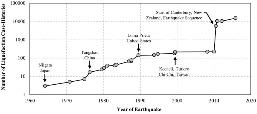
PRJ-2937: CPT-Based Liquefaction Case Histories Resulting from the 2010-2016 Canterbury, New Zealand, Earthquakes: A Curated Digital Dataset (Version 2)
Authors: M. Geyin, B. Maurer, B. Bradley, R. Green, S. van Ballegooy
This dataset consists of approximately 15,000 CPT-based liquefaction case-histories compiled from three earthquakes in Canterbury, New Zealand. The compiled, post-processed data is presented in a dense array structure, allowing researchers to easily access and analyze a wealth of information pertinent to free-field seismic liquefaction response for a series of earthquakes closely spaced in time.
PRJ-1648: University of Auckland Lightly Reinforced Concrete Wall Tests
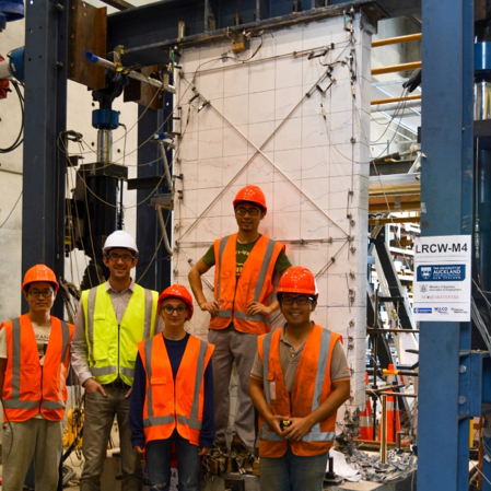
Authors: R. Henry and Y. Lu
A series of experimental tests of large-scale lightly reinforced concrete walls were conducted to investigate minimum vertical reinforcement provisions and formed the basis for revisions to the structural codes in New Zealand and the US. This dataset summarizes the results from the 11 tested walls including all sensor data (load cell, LVDT, string-pot displacement gauge, displacement transducer and strain gauge) and photos that were taken throughout the testing.
PRJ-2113: StEER - Hurricane Michael
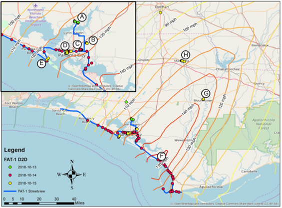
Authors: D. Roueche, T. Kijewski-Correa, J. Berman, A. Lyda with Cleary, Gurley, Marshall, Pinelli, Prevatt, Smith, Ambrose, Brown, Moravej, Palmer, Rawajfih, Rihner, Dafni, Yeung, Grasso, Johnson, Mongold
On October, 10 2018, Hurricane Michael made landfall just south of Panama City, FL. The natural hazards engineering community swiftly deployed a Field Assessment Structural Team (FAST) through StEER and a complementary reconnaissance team through the RAPID EF. The StEER team broadly assessed the performance of a representative subset of structural typologies in coastal and inland areas, while the RAPID collected using a variety of technologies including unmanned aerial vehicles, laser scanners and applied streetview.
PRJ-2290: Hurricane Matthew Storm Surge and Wave Simulations with Data Assimilation
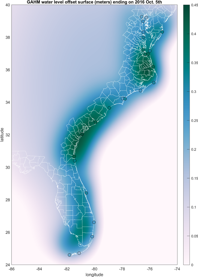
Lead Author: Taylor Asher
This dataset includes model simulations and data analyses in support of a study developing and testing a new data assimilation technique to improve coastal water level model accuracy. The study used three different sources for the model's wind and pressure (meteorological) inputs to force the ADCIRC+SWAN coupled ocean circulation and wave model for simulations of Hurricane Matthew (2016). Results showed that the data assimilation method substantially reduced model error by correcting for gradual errors in water levels. These data can be used for study of model hindcast performance, work on data assimilation methodology, or model sensitivity to meteorological inputs.
Related Links
PRJ-1648: University of Auckland Lightly Reinforced Concrete Wall Tests
PRJ-2113: StEER - Hurricane Michael
PRJ-2290: Hurricane Matthew Storm Surge and Wave Simulations with Data Assimilation