


FOR IMMEDIATE RELEASE
Community Resilience from Earthquakes and Tsunamis
Built, natural, and social environmental dataset wins 2023 DesignSafe Dataset award
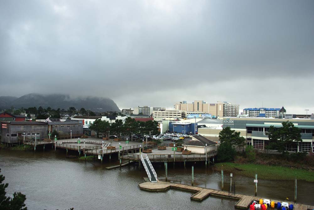 Seaside, Oregon (pictured) is the focus of study for community resilience in the crosshairs of hazardous earthquakes and tsunamis. Environmental data that included buildings, ground movement, and demographics were collected in work recognized with a 2023 DesignSafe Dataset Award. Credit: M.O. Stevens(opens a new window), Creative Commons 3.0.
A dataset on seismic and tsunami hazards of a coastal Oregon town has received a 2023 DesignSafe Dataset award, given in recognition of the dataset's diverse contributions to natural hazards research.
The resort town of Seaside, Oregon (pop. 7,115) was chosen as the focus of study that modeled community response in the crosshairs of potential disaster. Seasides low-lying topography and proximity to the Cascadia subduction zone make it extremely vulnerable to earthquakes and tsunamis.
"What we liked about Seaside is its small community size allowed us to look at very granular parcel-level information. Each building was accounted for in our study, rather than a bird's eye view of a larger area," said dataset principal investigator Dan Cox(opens a new window), a professor in Civil Engineering at Oregon State University.
Built, Natural, and Social Environmental Data
"We collected data on the built environment, including Seaside's infrastructure — its buildings, roads, bridges, water pipes, electric poles, and power lines," said dataset co-author Andre Barbosa(opens a new window), a professor in Structural Engineering at Oregon State University.
The dataset authors — which included Mohammad Alam (Notre Dame University, formerly at Oregon State University), Mehrshad Amini (Oregon State University), Sabarethinam Kameshwar (Louisiana State University), Hyoungsu Park (University of Hawaii at Manoa), and Dylan Sanderson (Oregon State University) — also collected natural hazards data resulting from probabilistic seismic-tsunami hazards.
The natural hazards data details peak ground acceleration and deformations, as well as maximum tsunami water inundation, velocity, and momentum in intervals ranging from 100 to 10,000 years.
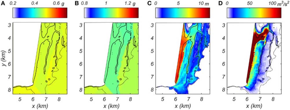 Spatial hazard maps of (A) peak ground acceleration, (B) Sa(T1 = 0.3 s), (C) hmax, and (D) (MF)max for 1,000-year event. Credit: DOI: 10.3389/fbuil.2017.00032(opens a new window).
What's more, the dataset includes social data in the form of household and housing unit characteristics allocated to individual houses and other buildings. This data includes demographics on the number of persons, race, whether owned or rented, vacancy, group quarters type, and estimated land use.
Community Resilience
"Our dataset is fairly unique in the sense that it combines built, natural, and human systems in a dataset that people can use for modeling community resilience," Cox said.
Community resilience encompasses the livelihood and functionality of the people affected before and after an impacting event.
"Resiliency depends on resources and the rapidity with which the community can actually bounce back." Barbosa said. "Resilience is a complex thing, but essentially it tells you how robust your infrastructure and social systems are, and how fast they can recover after that big extreme event."
Cox added: "We envisioned this data set as a tool that researchers can use to see, for example, how changes to the built environment might improve the resilience to one hazard or another, and whether there are solutions that can have multiple benefits to minimize the damage and loss from the two hazards combined."
DesignSafe Data Curation
The dataset, PRJ-3390 | Seaside Testbed Data Inventory for Infrastructure, Population, and Earthquake-Tsunami Hazard, is publicly available on the NHERI DesignSafe cyberinfrastructure (DOI: 10.17603/ds2-sp99-xv89(opens a new window)).
"DesignSafe was instrumental in helping us understand what possible formats the data set could take," Cox said. This knowledge helped the team build out a test bed that was unique in their field. "They really got us to think about what the structure of that data set could look like."
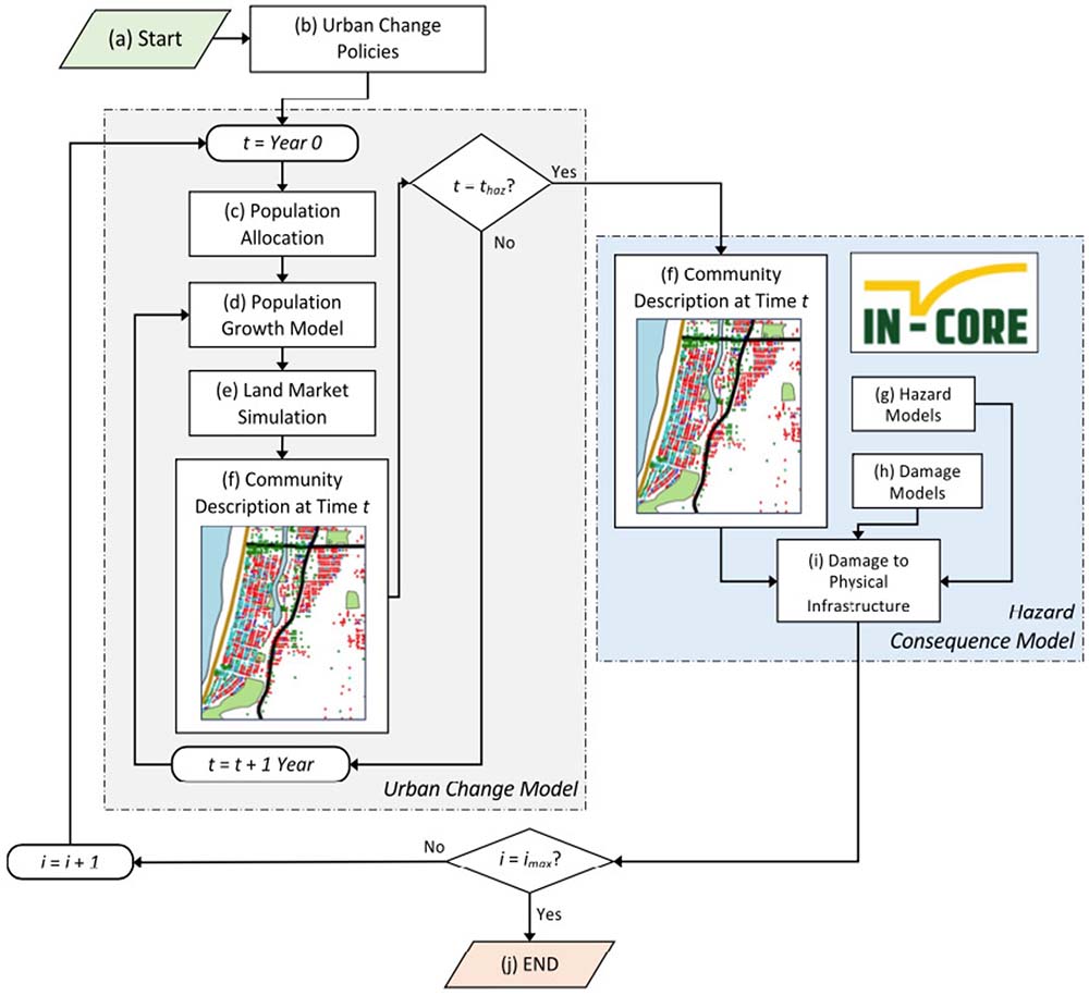 Flowchart of the coupled urban change (gray dash-dot box on left) and hazard consequence model (blue dash-dot box on right). Credit: DOI: 10.1029/2022EF003059(opens a new window).
"They also have tracking tools which are useful. We can contact DesignSafe later to see what improvements, if any, can be made on how we do the data sharing. And I really like that the dataset archive is centralized."
DesignSafe also provided the authors with helpful publishing tools and a direct object identifier (DOI) created for the dataset. The DOI allowed them to link the dataset to existing and future scientific papers. And the DOI allowed the students involved to receive credit for their work.
"The DesignSafe team has been instrumental in our being able to share the data effectively," Barbosa added. "I would like to give special thanks to Maria Esteva (Texas Advanced Computing Center/Natural Hazards Engineering Research Infrastructure). She was an especially big help in working with the students to come up with ideas of how to better organize the data."
Scientific Studies
The data in the Seaside Testbed (PRJ-3390) has been used in over a dozen scientific studies, including research published(opens a new window) December 2022 in the journal Earth's Future by the American Geophysical Society.
This study evaluated different policy options, some of which triggered actions, for example, on structural retrofits, where after a building gets sold, the owner is required to retrofit it. Other policies studied included the number of VRBOs (Vacation Rentals by Owner) that are allowed in a community, and what might be the unintended consequences if a large disaster were to happen.
 Andre Barbosa (L) and Dan Cox (R) of Oregon State University.
"It's a very unique study, because it integrates an urban change model with a lot of research that looks at the risk and impact of natural disasters on communities. But the urban change model with the risk is usually not coupled," Barbosa said.
Resilience Through Data and Modeling
"We need the data to be able to understand how decisions will impact the resilience of communities," Cox said. "It's just essential that we're able to pull data together and share it. Not just this one data set, but we need lots and lots of data sets that can just look at different types of communities and different types of hazards."
"Mitigation matters," added Barbosa. "In community resilience studies and with these types of datasets, communities and other researchers can start the different policies and mitigation strategies so that they can use and implement them and hopefully become more resilient."
DesignSafe is a comprehensive cyberinfrastructure that is part of the NSF-funded Natural Hazard Engineering Research Infrastructure (NHERI) and provides cloud-based tools to manage, analyze, understand, and publish critical data for research to understand the impacts of natural hazards. The capabilities within the DesignSafe infrastructure are available at no-cost to all researchers working in natural hazards. The cyberinfrastructure and software development team is located at the Texas Advanced Computing Center (TACC) at The University of Texas at Austin, with a team of natural hazards researchers from the University of Texas, the Florida Institute of Technology, and Rice University comprising the senior management team.
NHERI is supported by multiple grants from the National Science Foundation, including the DesignSafe Cyberinfrastructure, Award #2022469.