


The DesignSafe Dataset Awards
Outstanding Datasets Recognized Annually
The DesignSafe Dataset Awards recognize outstanding datasets published in the Data Depot data repository. Multiple Dataset Awards are recognized annually and the selection committee considers datasets across the different types of data models (e.g., experimental, simulation, hybrid simulation, field research, other). The selection criteria include:
- Quality and clarity of the curation
- Potential for data re-use
- Uniqueness of the dataset
Awards Selection and Recognition
Awards are announced every Spring. The authors associated with the selected datasets are:
- Recognized with a feature story on the DesignSafe website.
- Awarded a certificate and Amazon Gift card.
- Invited to give a presentation at a future DesignSafe workshop or webinar.
Eligibility & Nominations
Datasets published in DesignSafe between January 1 and December 31 of the designated year are eligible. Nominations open every Fall/Winter, and are announced on the website and via email.
2025 Awardees
Dataset PRJ-2769
Food Access Impact Survey for Harris County and Southeast Texas after Hurricane Harvey in 2017

Improved Predictions of Earthquake Damage
Ground motion intensity measures for earthquake liquefaction assessment win 2024 DesignSafe Dataset Award
Food insecurity is a chronic problem in the United States that annually affects over 40 million people under normal conditions. This difficult reality can dramatically worsen after disasters. Such events can disrupt both the supply and demand sides of food systems, restricting food distribution and access precisely when households are in a heightened need for food assistance. Often, retailers and food banks must react quickly to meet local needs under difficult post-disaster circumstances. Residents of Harris County and Southeast Texas experienced this problem after Hurricane Harvey made landfall on the Texas Gulf Coast in August 2017. The primary data collected by this project relates specifically to the supply side. The data attempt to identify factors that impacted the ability of suppliers to help ensure access to food, with a focus on fresh food access. Factors included impacts to people, property and products due to hurricane-related damage to infrastructure. Two types of food suppliers were the foci of this research: food aid agencies and food retailers. The research team examined food aid agencies in Southeast Texas with data collection methods that included secondary data analysis, a focus group and an online survey. The second population studied was food retailers with in-person surveys with store managers. Food retailers were randomly sampled in three Texas counties: Jefferson, Orange, and Harris. The data collection methods resulted in 32 food aid agency online survey responses and 210 completed food retail in-person surveys. Data were collected five to eight months after the event, which helped to increase the reliability and validity of the data. The time-sensitive nature of post-disaster data requires research teams to quickly organize their efforts before entering the field. The purpose of this project archive is to share the primary data collected, document methods, and to help future research teams reduce the amount of time needed for project development and reporting.
The Food Access Restoration Model dataset represents a fully reproducible data science workflow. This dataset builds on datasets archived on DesignSafe which include social science and engineering elements. The research team includes researchers, professors, post-docs, PhD students, graduate students, and community partners. All of whom are included as either co-authors or data collectors within the metadata sections of the project. In addition to the data, the dataset includes replication code, a pre-print version of the journal article, presentations, and data documentation. The dataset was included in the reference section of the published journal article and refers to other datasets for primary data, secondary data, and survey instruments. This dataset represents the full potential of the DesignSafe-CI field research data model.
Principal Investigator: Nathanael Rosenheim
Dataset PRJ-5700
Virtual Damage Assessment and First-floor Elevation Estimation: Application to Fort Myers Beach, Florida and Hurricane Ian (2022)

The Faces of Disaster
Social vulnerability spotlighted in 2024 NHERI DesignSafe Dataset Award winner
Several field work and reconnaissance data -primarily pre- and post-storm street-level and aerial imagery- were used to create a comprehensive collection of datasets for virtual damage assessment (VDA) and first-floor elevation (FFE) measurements of 3,408 building structures impacted by Hurricane Ian (2022) in Fort Myers Beach, Florida. The methodology was implemented using engineering students and was validated through a cross-comparison between student and expert opinions. The VDA data includes component-based damage assessment on a damage state (DS) scale from no damage (DS0) to complete damage (DS6) for roof, walls, elevated floors, windows and doors, attachments, and foundations to estimate the overall damage to the structure. The FFE data includes foundation type based National Flood Insurance Program (NFIP) guidelines which are managed by the Federal Emergency Management Agency (FEMA). This dataset also integrates publicly available data utilized in this project, including: (1) National Structural Inventory (NSI), (2) Lee County Damage Assessment (LCDA), (3) Tax Assessor (TA), (4) Florida Elevation Certificate (FEC), (5) surge/wave data based on high-water marks (HWMs). This collection of datasets can be utilized to improve understanding of hurricane damage to buildings, which can lead to the development of reliable models to predict damage in coastal communities.
Principal Investigator: Mehrshad Amini
Co-PIs: Daniel Cox, Andre Barbosa, Sebastiao Appleton Figueira
2024 Awardees
Dataset PRJ-4022
Consistently computed ground motion intensity measures for liquefaction triggering assessment

Improved Predictions of Earthquake Damage
Ground motion intensity measures for earthquake liquefaction assessment win 2024 DesignSafe Dataset Award
The state of practice for assessing soil liquefaction relies on manifestation models developed from databases of liquefaction field case histories. A key component of these case histories is the seismic demand that led to soil liquefaction triggering or the absence thereof. Traditionally, this seismic demand is represented by the peak ground acceleration (PGA), supplemented with the earthquake magnitude (M). The PGA values have generally been estimated using various methods. For instance, some PGAs were considered equal to the recorded PGA at a nearby seismic station, or estimated using ground motion models, 1D site response analyses, or judgment. This data release consists of PGA values at case history sites in the Next Generation Liquefaction (NGL) database, computed using a consistent approach based on Kriging interpolation and spatial correlation models developed using Bayesian inference. Values for three additional ground motion intensity measures (IMs) are also computed: peak ground velocity (PGV), cumulative absolute velocity (CAV), and Arias Intensity (AI). This data release replicates the ground motion IMs available in the NGL database (http://nextgenerationliquefaction.org). The developed spatial correlation models and recorded ground motion IMs used in this study are also included. This release aims at making these data available to a broader audience of researchers.
Authors: Renmin Pretell, Scott Brandenberg, Jonathan Stewart
Dataset PRJ-4241
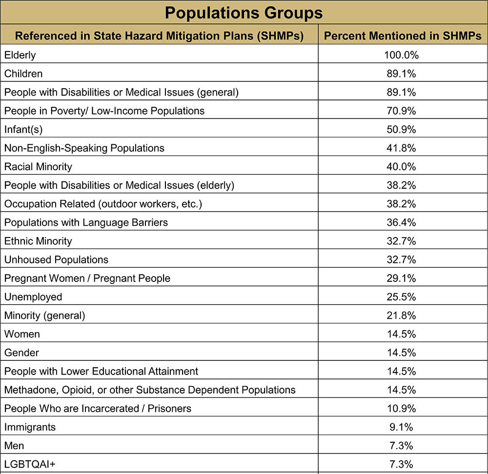
State Hazard Mitigation Plans and Social Vulnerability
The Faces of Disaster
Social vulnerability spotlighted in 2024 NHERI DesignSafe Dataset Award winner
U.S. state, territorial, and tribal government officials develop State Hazard Mitigation Plans (SHMPs) to assist in reducing the risk of disaster impacts on people, physical infrastructure, and the natural environment. The Federal Emergency Management Agency (FEMA) approves SHMPs every five years as a requirement to be eligible to receive funding for FEMA disaster relief grants and disaster mitigation projects. As of April 2023, FEMA updated policy guidance for SHMPs is in effect that calls for greater community engagement in the planning process and stipulates that plans consider equity and climate change. In response to these changes and research in this area, this project takes the position that more robust conceptualizations and inclusive use of social vulnerability data can help states in the development of multi-hazard risk assessments. Social vulnerability emerges from systemic inequities, resulting in populations facing disproportionate impacts in disasters. It is a helpful framework for identifying underserved and marginalized populations. Given the crucial importance of considering social vulnerability in mitigation planning, our research team built a novel dataset with descriptive data of the populations, definitions, and different measures of social vulnerability included in SHMPs for all 50 states and 5 inhabited U.S. territories. This project includes: (1) the State Hazard Mitigation Plan data; (2) a data dictionary with description of each variable output; and (3) variable definitions for the population groups included in State Hazard Mitigation Plans. This dataset allows for quantitative analysis of the inclusion (or exclusion) of vulnerable populations in SHMPs. Additionally, this dataset can help State Hazard Mitigation Officers and their partners identify gaps in addressing social vulnerability as they update the SHMPs for the areas they serve. These resources are available to all who are interested in addressing social vulnerability in hazard mitigation planning, either through research or in practice.
Authors: Lori Peek (PI), Mary Angelica Painter, Melissa Villarreal
2023 Awardees
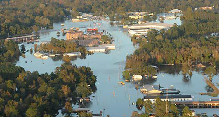
Dataset PRJ-3390
Seaside Testbed Data Inventory for Infrastructure, Population, and Earthquake-Tsunami Hazard
Community Resilience from Earthquakes and Tsunamis
Built, natural, and social environmental dataset wins 2023 DesignSafe Dataset award
This dataset associated with a multi-hazard testbed for infrastructure resilience in Seaside, Oregon developed for the NIST Community Resilience Center of Excellence. Seaside is located along the Oregon coast and is subject to both seismic and tsunami hazards associated with the Cascadia Subduction Zone. The size of Seaside lends itself to parcel-level analyses of multi-infrastructure damage, loss, and recovery modeling. Datasets are provided for built-, natural-, and social-systems in Seaside. The built environment consists of buildings, electric power, transportation, and water infrastructures. The natural environment (hazards) are the result of a probabilistic seismic-tsunami hazards analysis and the social systems consist of results from a housing unit allocation. Researchers, decision makers, and planners, among others, can utilize these datasets to conduct community-scale multi-hazard risk assessment, focusing on application to the coastal urban city of Seaside, Oregon.
Authors: Daniel Cox (PI), Andre Barbosa, Mohammad Alam, Mehrshad Amini, Sabarethinam Kameshwar, Hyoungsu Park, Dylan Sanderson
Dataset PRJ-3499
ARkStorm 2.0: Atmospheric Simulations Depicting Extreme Storm Scenarios Capable of Producing a California Megaflood
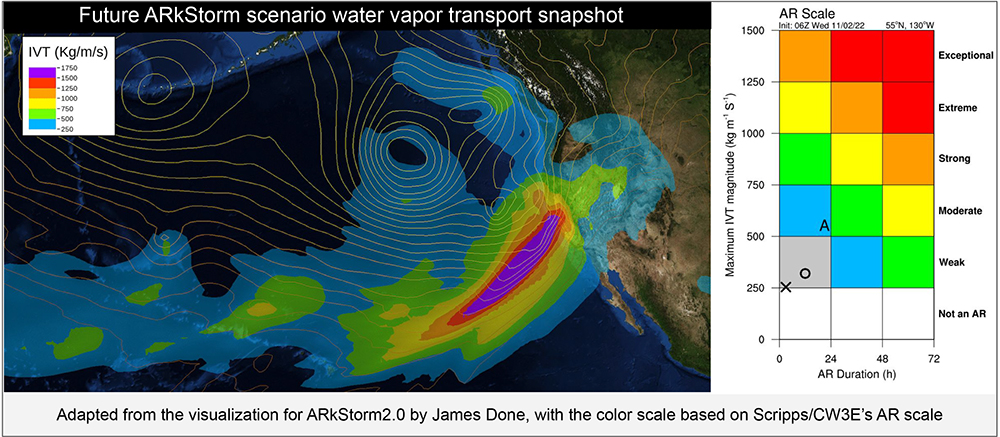
California Flooding from the ARkStorm
Climate-induced storm flood data wins 2023 DesignSafe Dataset awards
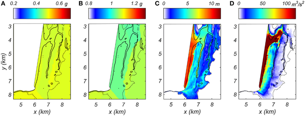
ARkStorm 2.0 is a cross-disciplinary flood emergency management and climate adaptation scenario aimed at quantifying the "plausible worst case" flood scenarios in California in a warming climate. It builds upon the previous ARkStorm 1.0 simulation exercise by incorporating the influence of climate change and by using a systematic, physically-based approach to scenario event selection. The data included include initial condition, forcing, and configuration files for the Weather Research and Forecasting Model (WRF) simulations used to develop the hypothetical extreme storms. It also includes WRF output files containing various meteorological variables (including, but not limited to, precipitation, wind, snow water equivalent, and surface runoff) that may be of interest in characterizing natural hazard impacts. These data are intended to be used in the development of meteorological scenarios, hydrologic simulations, risk assessments, and other activities aimed at quantifying and mitigating natural hazard risk in California stemming from extreme winter storms in a warming climate.
Authors: Xingying Huang, Daniel Swain
2022 Awardees
Dataset PRJ-1379
Experimentally Validated Stochastic Numerical Framework to Generate Multi-Dimensional Fragilities for Hurricane Resilience Enhancement of Transmission Systems
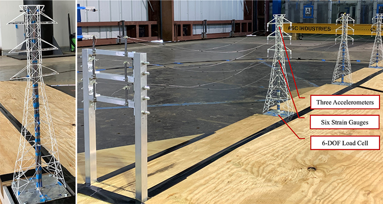
The dataset evaluates a scaled aeroelastic model of a self-supported steel-lattice transmission tower and a multi-span transmission line system subjected to simulated hurricane winds. The aeroelastic tests were conducted at the NSF Wall of Wind Experimental Facility at the Florida International University. Their dataset contains three experiments on different models that include a single tower without insulators, three towers with conductors, and three towers with ruptured conductors.
Authors: Ziad Azzi, Ashkan Bagheri Jeddi, Amal Elawady, Arindam Gan Chowdhury, Yousef Mohammadi Darestani, Abdollah Shafieezadeh, James Erwin, and Dejiang Chen
Dataset PRJ-2828
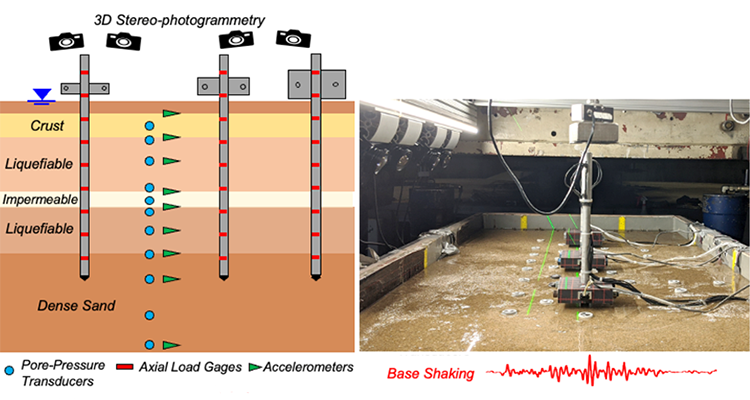
Centrifuge Testing of Liquefaction-Induced Downdrag on Axially Loaded Piles
Bridges Under Pressure
Liquefaction-induced downdrag on pile foundations data wins 2022 DesignSafe Dataset Award
The dataset investigates how liquefaction-induced downdrag can add to the structural load applied to a pile foundation during earthquake shaking. The data was generated by inducing liquefaction in scale soil models in the University of California, Davis Geotechnical Centrifuge. Their dataset includes two well-documented experiments, one with uniform and the other with interbedded liquefiable deposits.
Authors: Sumeet Kumar Sinha, Katerina Ziotopoulou, and Bruce Kutter
Dataset PRJ-2143
Experimental Investigation of Wave, Surge, and Tsunami Transformation over Natural Shorelines
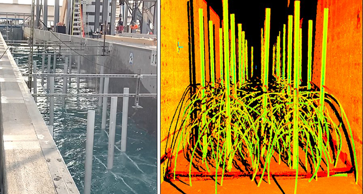
The dataset examines the potential of mangroves to attenuate wave heights and reduce loads on sheltered structures through a prototype-scale physical model. The tests were performed at the NHERI Experimental Facility at Oregon State University. Their experiment considers six different model layouts that consider the effectiveness of combining three levels of mangrove density with the presence or absence of a structural barrier.
Authors: Kiernan Kelty, Tori Tomiczek, Daniel Cox, and Pedro Lomonaco
Dataset PRJ-3324
Personal Heat Exposure

Feeling the Heat
Personal heat exposure wins 2022 DesignSafe Dataset Award
The dataset assesses the health impact of a simultaneous city-wide power outage and heatwave in the cities of Phoenix, Arizona; Detroit, Michigan; and Atlanta, Georgia. The data includes both quantitative data in the form of temperature and humidity measurements made with sensors provided to each human participant as well as qualitative data in the form of participant-completed time-activity diaries that document their experiences. This dataset represents one of the first published social science datasets in DesignSafe.
Authors: Lance Watkins, Mary Wright, Paul Chakalian, Elizabeth Kurtz, and David Hondula
2021 Awardees
Dataset PRJ-2113
StEER - Hurricane Michael
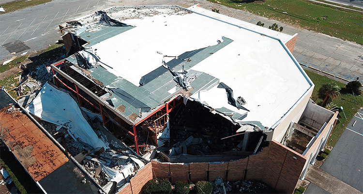
Learning from Hurricane Michael
StEER post-event reconnaissance helps assess building response to historic storm
On October, 10 2018, Hurricane Michael made landfall just south of Panama City, FL. The natural hazards engineering community swiftly deployed a Field Assessment Structural Team (FAST) through StEER and a complementary reconnaissance team through the RAPID EF. The StEER team broadly assessed the performance of a representative subset of structural typologies in coastal and inland areas, while the RAPID collected using a variety of technologies including unmanned aerial vehicles, laser scanners and applied streetview.
Authors: D. Roueche, T. Kijewski-Correa, J. Berman, A. Lyda with Cleary, Gurley, Marshall, Pinelli, Prevatt, Smith, Ambrose, Brown, Moravej, Palmer, Rawajfih, Rihner, Dafni, Yeung, Grasso, Johnson, Mongold
Dataset PRJ-1648
University of Auckland Lightly Reinforced Concrete Wall Tests
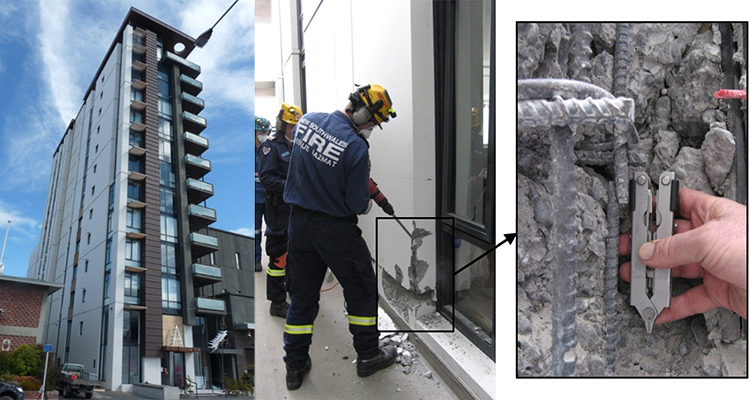
Christchurch Earthquake Damage Mystery Spurs Research
Concrete wall seismic test data using DesignSafe-CI portal helps revise New Zealand and U.S. building code
A series of experimental tests of large-scale lightly reinforced concrete walls were conducted to investigate minimum vertical reinforcement provisions and formed the basis for revisions to the structural codes in New Zealand and the US. This dataset summarizes the results from the 11 tested walls including all sensor data (load cell, LVDT, string-pot displacement gauge, displacement transducer and strain gauge) and photos that were taken throughout the testing.
Authors: R. Henry and Y. Lu
Dataset PRJ-2290
Hurricane Matthew Storm Surge and Wave Simulations with Data Assimilation
On the Level with Hurricane Matthew
Data assimilation using DesignSafe-CI portal improves coastal water level models of storm surge
This dataset includes model simulations and data analyses in support of a study developing and testing a new data assimilation technique to improve coastal water level model accuracy. The study used three different sources for the model's wind and pressure (meteorological) inputs to force the ADCIRC+SWAN coupled ocean circulation and wave model for simulations of Hurricane Matthew (2016). Results showed that the data assimilation method substantially reduced model error by correcting for gradual errors in water levels. These data can be used for study of model hindcast performance, work on data assimilation methodology, or model sensitivity to meteorological inputs.
Lead Author: Taylor Asher
Dataset PRJ-2937
CPT-Based Liquefaction Case Histories Resulting from the 2010-2016 Canterbury, New Zealand, Earthquakes: A Curated Digital Dataset (Version 2)
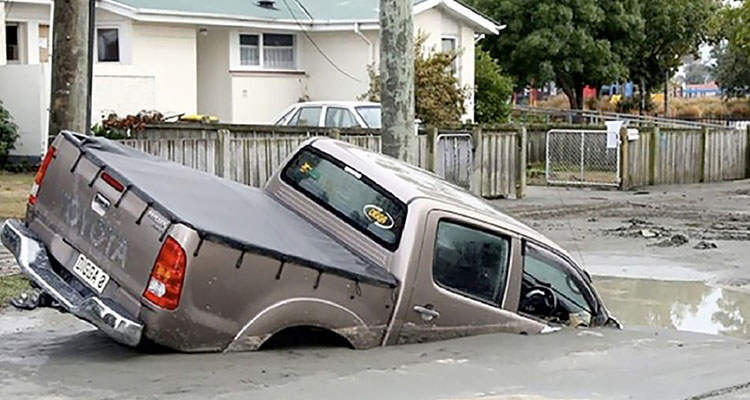
Sinking After Earthquakes
Treasure-trove of 2010-2016 Canterbury earthquake liquefaction case histories shared
This dataset consists of approximately 15,000 CPT-based liquefaction case-histories compiled from three earthquakes in Canterbury, New Zealand. The compiled, post-processed data is presented in a dense array structure, allowing researchers to easily access and analyze a wealth of information pertinent to free-field seismic liquefaction response for a series of earthquakes closely spaced in time.
Authors: M. Geyin, B. Maurer, B. Bradley, R. Green, S. van Ballegooy